Gaylord
Vanderbilt
Indian River
Topinabee
Cheboygan
Mackinac City
Home>Your Interests>Blueways>Cheboygan Area Blueway
INFORMATION ON TRAIL SECTIONS
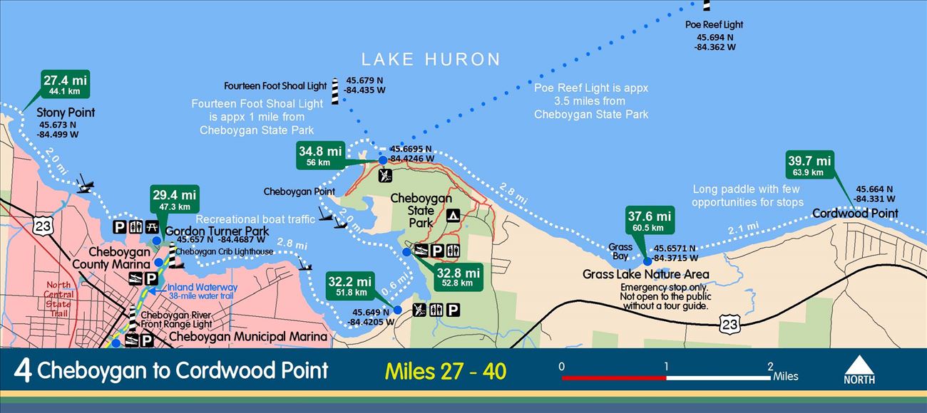
Route: JON KELDSEN ROADSIDE PARK TO CHEBOYGAN STATE PARK
Distance: 13 Miles
Access Sites: 02-01 & 02-04
Shoreline Land Use: Waterfront residential except for State Park
Points of Interest: Cheboygan State Park, Lighthouse Point, Grass Lake Nature Area
Rest Stops: Only rest stops in Cheboygan State Park
Hazards & Cautions: Very long paddle without opportunities for rest stops outside the Cheboygan State Park
Comments: Grass Lake Nature Area is not open to the public without a tour guide.
Route: DUNCAN BAY
Distance: 2-3 Miles
Access Sites: 02-04 & 02-10
Shoreline Land Use: Waterfront residential and undeveloped.
Points of Interest: Coastal wetlands
Rest Stops: Cheboygan State Park Beach
Hazards & Cautions: Recreational boat traffic from the Cheboygan River
Comments: Offers short paddle in a more protected bay.
Route: CHEBOYGAN RIVER
Distance: 3 Miles
Access Sites: 02-10
Shoreline Land Use: Commercial and residential
Points of Interest: City waterfront with commercial and restaurants.
Rest Stops: 02-08, 02-07, 02-06
Hazards & Cautions: Recreational boat traffic can be heavy during summer, especially on weekends
Comments: There are a dam and locks near Lincoln Street. The Cheboygan River is part of the inland waterway that connects the city of Cheboygan to Conway near Petoskey. Remember if paddling upstream from the river mouth, you’ll be paddling against the current.
Route: CHEBOYGAN DAM TO CONFLUENCE OF CHEBOYGAN AND BLACK RIVERS
Distance: 2.5 Miles
Access Sites: 02-06 DNR Boat Launch
Shoreline Land Use: Residential and commercial
Points of Interest: Bridges, restaurants and parks
Rest Stops: There are no rest stops along this section
Hazards & Cautions: Recreational boat traffic can be heavy during summer, especially on weekend There is a dam and locks near Lincoln Street.
Comments: The Cheboygan River is part of the inland waterway that connects the city of Cheboygan to Conway near Petoskey. Remember if paddling upstream from the river mouth, you’ll be paddling against the current.
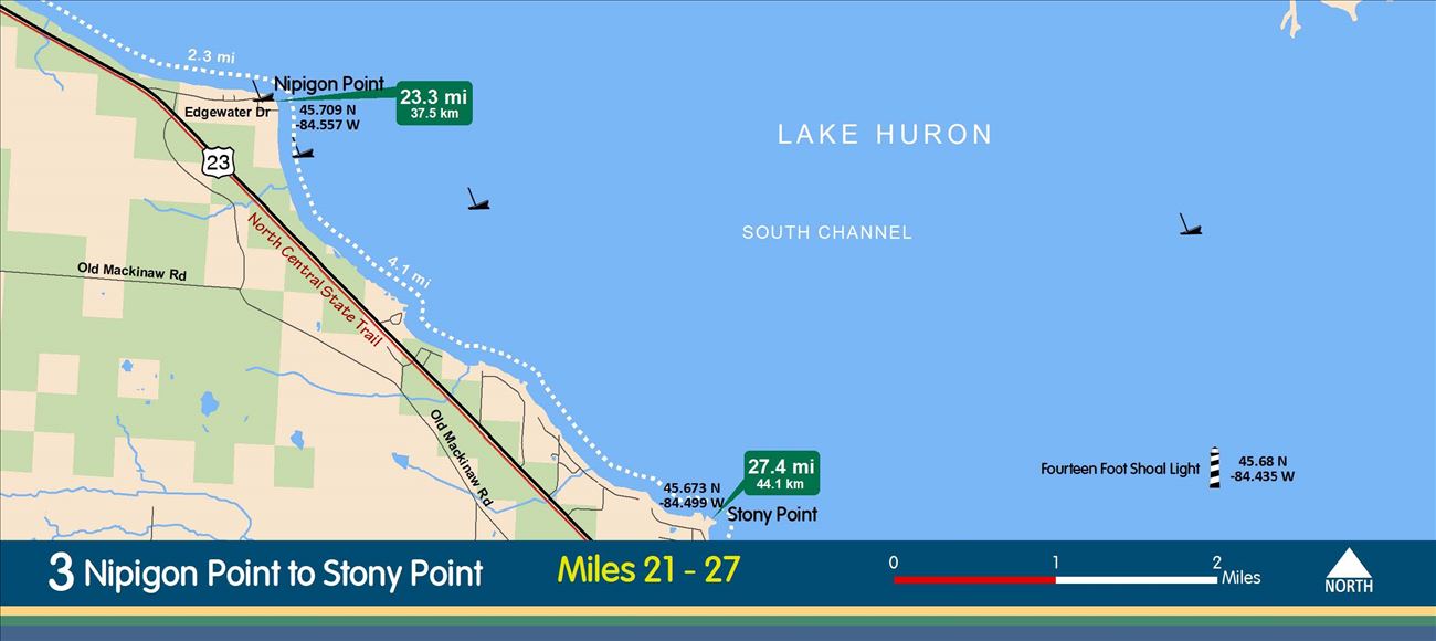
Route: CHEBOYGAN TO RICHARD KUZMA ROADSIDE PARK
Distance: 8.2 Miles
Access Sites: 02-10 & 02-11
Shoreline Land Use: Waterfront residential
Points of Interest: Coastal marshes near Cheboygan, Nipigon Point and views of freighters, Mackinac Bridge, Bois Blanc Island and Mackinac Island
Rest Stops: There are no rest stops
Hazards & Cautions: There are no rest stops along this section.
Comments:
Viewing this on a mobile device? Use the mobile edition of this website!
Copyright © 2015, Northeast Michigan Council of Governments | Contact the US 23 Heritage Route!
This website powered by Community Center software from LIAA